Sunday, April 24, 2011

Conformal projections


Conformal projections
https://www.e-education.psu.edu/natureofgeoinfo/c2_p22.html

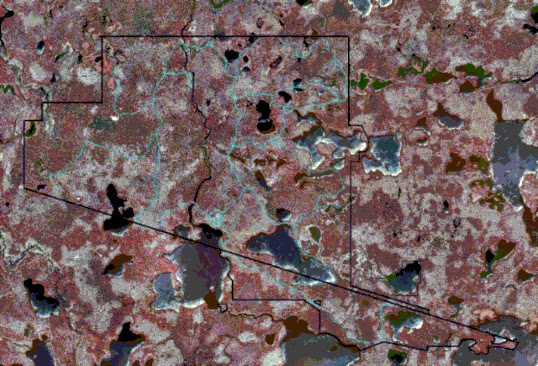
A conformal projection is a type of map projection that keep the true shape of the area as much as possible using different conic projection methods. As you can see the areas that have the most similar sized circles maintain the most accurate true shape.

Map Projection


Map Projection
http://www.mapsanddirections.us/projections.htm

The above image is a simple example of a map projection of the world. It is a basic and general perception of the world. 

GIS


GIS
http://www.landsofamerica.com/landsconnector/mother-earth-news/index.cfm?action=propertyDetails&inv_id=237280

A GIS map is a projection of a geographic information system through the use of satellite imaging and other technologies. When you use a GIS map, you are also choosing to use a geodetic datum. The image above is a demonstration of satellite imaging through the use of GIS technology that allows a viewer to accurately see a certain region or area that is being looked at.

Geoid Map


Geoid Map

Geodesists devised geoids, mathematical surfaces that can be used to establish and standardize vertical (elevation) positions. A geoid subtracts out the deformation of the crust due to rock density and gravity. Different colors are used ti demonstrate the different elevations and land distortions on this map. The map above shows how different parts of the earths surface vary in elevation through the use of saturated colors of blue, green, orange, yellow, purple, and so forth.

Ellipsoid


Ellipsoid

An ellipsoid map is a type of map projection that allows a viewer to get an accurate perception of certain characteristics such as elevation or precipitation of a specific area or region.  

GPS


GPS

GPS is a global positioning system that allows a user to accurately view a specific location of something at a specific time. Usually used to see where you are and how to get somewhere. The map above shows what a GPS image looks like when a user activates their GPS device.

Satellite Map


Satellite Map

A satellite map is a map that projects a satellite image take from outer space. The photo above is an example of a satellite map because it is a image that was taken by a satellite.

Abstract Map


Abstract Map

Abstract maps show a certain area or place without giving away any real or concrete information. This map is an abstract representation of space that shows the basic geopolitical boundaries of the world and is superimposed on a satellite image of the world.

Cyber Space Map


Cyber Space Map

The map above is an example of a cyberspace map because of its abstract demonstration of the connection cyberspace has throughout the United States. You can see how each of the lines represent a certain connection to various internet connections and where they are directed to. This image maps out how certain regions are connected to one another through cyberspace.

Stick Map


Stick Map

A stick map is a map that is made up of sticks that represent roads or directions; the image above in an example of this.  You can see how each of the sticks could represent a direction or road or a path that the person who made the map wanted a viewer to see and follow.

Mental Map


Mental Map

Humans have been making maps since the beginning of time. Maps are more than just the typical two-dimensional piece of paper we use to navigate with when driving in the car. Mental maps are the personal perception an individual has on what they see; the image above is an example of a mental map.

Bivariate choropleth maps


http://proceedings.esri.com/library/userconf/proc99/proceed/papers/pap171/p171.htm

A bivariate choropleth map combines two set of colors of geographic symbols in order to show different variables on a map. The map above demonstrates this with the different variations of the color red in order to show Ohio population in 1997.

Unclassed choropleth maps


Unclassed choropleth maps
http://krygier.owu.edu/krygier_html/geog_353/geog_353_lo/geog_353_lo07.html

An unclassed choropleth map doesn't use the element of color in order to differentiate between any geographical characteristics of the region being mapped. Obviously the two maps above lack the use of color and therefore are seen to be an unclassed choropleth map.

Classed choropleth maps


Classed choropleth maps
http://courses.washington.edu/info424/Labs/ChoroplethMap.html

A classed choropleth map uses the element of color in order to differentiate between different pieces of information being portrayed on a map. The above image uses variations of the color purple and green in order to convey certain pieces of information to the viewer.

Cartographic animations


Cartographic animations
http://cartography2.org/Chapters/page6/OverviewAnimated.html

Cartographic animations convey different pieces of information on a map through animation. The photo above shows the surface total precipitation and wins along with clouds and reflectivity while using shaped animations to convey this information to the viewer.

Statistical maps


Statistical maps
http://mappery.com/Southwestern-College-Campus-Map

Statistical maps are maps based on certain statistics of any given region or area. Variations in factors such as population, precipitation or any other geographical characteristics are usually what statistical maps such as the one above are based upon.

Cartograms


Cartograms
http://agro.biodiver.se/2007/03/singer-cartogram/

Cartograms are maps that show an area based upon statistical data. The map is usually distorted from the actual relative size of a region and replaced with whatever statistical data the map is based upon. The map above is based upon the agricultural biodiversity of the world and thus represented as such.

Flow maps


Flow maps
http://infosthetics.com/archives/2007/02/cartographic_flow_map_layout.html

A flow map or flow chart like the one above demonstrate the connection between different pieces of information and "flow" in accordance to where they are on the map. Flow maps show the movement of different objects from one place to another.  A flow map also has the ability to show the process of something starting with the beginning and leading all the way towards the final process.

Isoline maps


Isoline maps
http://regentsprep.org/regents/core/questions/questions.cfm?Course=ESCI&TopicCode=07

An isoline map is a map that connects equal points of value such as elevation. The continuous lines that are connected like in the map above have an equal value to them.Commonly an isoline map is used in weather in order to indicate certain atmospheric pressures or variations in elevations that have an effect on the climate.

Proportional circle maps


Proportional circle maps

Proportional circle maps display information in relation to circles on a map. However many circles in a certain area represents a specific amount or set of data in that certain area. The map above is showing the frequency of tsunamis around the world and where they have had the most effect.

Choropleth maps


Choropleth maps
http://axellelormans.wordpress.com/2010/02/

Choropleth maps use variation in color in order to convey certain pieces of information. The photo above uses the variation of the color blue in order to demonstrate the change of divorce rates over time and how many have occurred over time in certain areas of the United States.

Dot distribution maps


Dot distribution maps
http://aede.osu.edu/programs/exurbs/popmaps.htm

Dot distribution maps are maps that use dots in order to show the presence of a certain characteristic, phenomenon or geographical feature like population density of a certain region. The map above is showing the population density of a certain region; the more dense the amount of dots, the more dense the population of that area is.

Propaganda maps


Propaganda maps
http://www.historum.com/general-history/9905-propaganda-maps.html

The map above is a Chinese propaganda map that shows how a certain person or group of people view the world and want to use the map in order to persuade other viewers. This map has the ability to shape how people interact, perceive, and conceptualize the world. The Russian octopus is smothering the rest of the eastern part of the world; this is obvious use of propaganda.

Hypsometric maps


Hypsometric maps
http://www.reliefshading.com/colors/hypsometric.html

Hypsometric maps use variations of color and shading in order to represent different elevations. The different shades represent different variation of relief in that specific area.

PLSS maps


PLSS maps
http://www.rootsweb.ancestry.com/~alfrankl/landrecords.htm

PLSS, Public Land Survey System, maps use a system based on the grid of townships and ranges and break up the area being looked at into those different sections.  It's used in order to divide up public land owned by the federal government. The above map shows how the PLSS is used in order to divide up the land in Franklin County, Alabama.

Cadastral maps


Cadastral maps
http://www.icsm.gov.au/mapping/maps_cadastral.html

Cadastral maps are used to provide specific information about a real piece of property within a certain area. These maps are used in order to show information such as tax rates, ownership information, property rights or even location in relation to specific area characteristics such as school zones or park areas.

Thematic map


Thematic map
http://www.census.gov/geo/landview/lv6help/lv6_faq.html

A thematic map is a type of map or chart used to show a certain theme such as census tracts that are connected with a specific geographic area.

Star plots


Star plots
http://www.math.yorku.ca/SCS/sugi/sugi16-paper.html

Star plots can be used in order to 

Correlation matrix


Correlation matrix
http://yin.che.wisc.edu/images.htm

A correlation matrix shows the correlation of a specific set of statistical data. Shown above is a calculated protein correlation matrix for phage T7. Based on the legend next to the matrix one can determine the correlation of the calculated protein. This can also be used in maps to show environmental or geographical data.

Similarity matrix


Similarity matrix
http://iv.slis.indiana.edu/sw/simvis.html

A similarity matrix simply shows the similarities between two data points.  

Stem and leaf plot


Stem and leaf plot
http://mainland.cctt.org/mathsummer/JosephBond/StemAndPlots/stem-and-leaf_std.htm

According to google definitions, a stemplot (also known as a stem-and-leaf plot), in statistics, is a device for presenting quantitative data in a graphical format, similar to a histogram, to assist in visualizing the shape of a distribution.

Box plot


Box plot
http://support.sas.com/rnd/base/topics/statgraph/proctemplate/a002650843.htm

Box plots are used in order to decipher different pieces of numerical information. In the graph above, the box plot is being used to show the differences in distribution of conditional residual by person in a specific area.

Histogram


Histogram
http://www.jamesmiller.com/Daisy2011/horizontalhistogram.html

A histogram is a graph that compares two different sets of data on an x and y-axis coordinate plane. 

Parallel coordinate graph


Parallel coordinate graph
http://vis.lbl.gov/Events/SC07/Drosophila/

Triangular plot

http://www.pazsoftware.com/Ternary5.html

Triangular plots can be used along with different symbols in order to convey different types of information. This plot normalizes and pots three different values on three separate graphs and then combines them to make a more standard plot onto the triangular plot. 

Windrose


Windrose
http://snr.unl.edu/data/climate/wind.asp

A windrose is used in order to track and record different weather patterns. The windrose above of Nebraska, plots hourly occurrence values from 1996-2005; viewers can see the specific yearly and monthly wind rose plots in order to get an accurate idea of what the weather will be like during certain times of the year or month.

Climograph


Climograph
http://www.uwsp.edu/geo/faculty/lemke/geog101/lectures/09_global_climate_patterns.html

Climographs show the average precipitation trends of a certain area or region. In the climograph above, you can see the average precipitation and temperature of Walgett, Australia over a years time. Graph like these help travelers when planning trips to unfamiliar places.

Population profile


Population profile
http://aspe.hhs.gov/hsp/prison2home02/Cadora.htm

A population profile simply shows the % of a regions population in which certain age groups are most popular. In the maps above the population profile shows the % of the population of Brooklyn, New York that is under the age of 18 and the amount of homes that are run under a single parent household.

Scatterplot


Scatterplot
http://itl.nist.gov/div898/handbook/eda/section3/eda33q.htm

A scatterplot is a graph that shows a set of information without there being any correlation between the set of data. According to the engineering statistic handbook, a scatter plot reveals relationships or association between two variables. The relationship have a somewhat random structure such as in the scatterplot above.

Index value plot


http://www.ct.gov/dep/cwp/view.asp?a=2684&q=322062&depNav_GID=1744

An index value plot is a type of map visualization that allows a viewer to visually see trends. The map above shows the ozone design value trends in Connecticut between the years of 1983 and 2010. 

Lorenz Curve


Lorenz Curve
http://www.answers.com/topic/lorenz-curve

According the google definitions, the Lorenz Curve is a graph on which the cumulative percentage of total national income is plotted against the cumulative percentage of the corresponding population. The image above is a basic demonstration of this curve that shows where equal distribution would be and compares it to the actual curve of the % of the population incomes actually cover.

Bilateral graph


Bilateral graph

A bilateral graph just shows different pieces of corresponding information on a x-axis and y-axis coordinate plane. The graph above shows Gross Public Expenditure on Development 2002/03 – 2006/07.

Nominal area choropleth map


Nominal area choropleth map

A nominal area choropleth map shows a certain area in relation to colors to demonstrate different sets of data. The map of Africa above just shows the quantitative variations between the different countries in Africa.

Range graded proportional circle map


Range graded proportional circle map

Continuously variable proportional circle map


Continuously variable proportional circle map

According to the website where I got this image (Nina Roberts), One circle represents the number of  persons of German ancestry in each community area.  Four circle sizes are used, each indicating a logarithmic increase in represented data.  The number of people symbolized by each circle ranges from 10 for the smallest circle to 1000 for the largest. Each circle in a continuously variable proportional circle map represents a specific set of data that is being examined in that certain area.

DOQQ


DOQQ
http://www.nd.edu/~underc/east/maps/

A DOQQ, a Digital Orthophoto Quarter Quads, uses infrared GIS technology in order to get a basic image of a certain area or region. This DOQQ aerial photo is used by the Environmental Research Center in order to keep an accurate idea of what sort of impact certain things have on this area; especially any of the habitats (grasslands, montane forest, and streams) that are in this region. The image above is a false color infrared imagery  which helps delineate surface features.

DEM


DEM
http://members.shaw.ca/davepatton/demcompare.html

A DEM, Digital Elevation Model, is used to show the elevation of a certain area or region. In the image above you can see the 3D image of an area and easily see where there is a higher elevation in this region of Canada.

DLG


DLG
http://weather.unisys.com/usgs/3sec/index.php

A DLG is a Digital Line Graph that is used in GIS systems in order to show a certain area or region. They have the ability to show different types of geographic activity such as boundaries, hydrography, vegetation and so forth. The map above is demonstrating different elevations in the United States. By using the legend, you can determine the different elevation based on the colors on the map.

DRG


DRG
http://egsc.usgs.gov/isb/pubs/factsheets/fs08801.html

A DRG, Digital Raster Graphic,  is used in order to project  an area showing elevations, water, or location of certain geographic features such as in the map above of the District of Columbia. You can see the topographic information of the graph from the different colors and contour lines.