Map Catalog
Sunday, April 24, 2011
Conformal projections
Conformal projections
https://www.e-education.psu.edu/natureofgeoinfo/c2_p22.html
A conformal projection is a type of map projection that keep the true shape of the area as much as possible using different conic projection methods. As you can see the areas that have the most similar sized circles maintain the most accurate true shape.
Map Projection
Map Projection
http://www.mapsanddirections.us/projections.htm
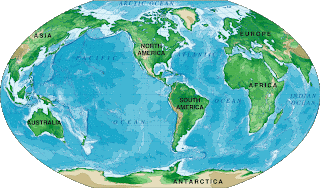
The above image is a simple example of a map projection of the world. It is a basic and general perception of the world.
GIS
GIS
http://www.landsofamerica.com/landsconnector/mother-earth-news/index.cfm?action=propertyDetails&inv_id=237280
A GIS map is a projection of a geographic information system through the use of satellite imaging and other technologies. When you use a GIS map, you are also choosing to use a geodetic datum. The image above is a demonstration of satellite imaging through the use of GIS technology that allows a viewer to accurately see a certain region or area that is being looked at.
Geoid Map
Geoid Map
Geodesists devised geoids, mathematical surfaces that can be used to establish and standardize vertical (elevation) positions. A geoid subtracts out the deformation of the crust due to rock density and gravity. Different colors are used ti demonstrate the different elevations and land distortions on this map. The map above shows how different parts of the earths surface vary in elevation through the use of saturated colors of blue, green, orange, yellow, purple, and so forth.
Satellite Map
Satellite Map
A satellite map is a map that projects a satellite image take from outer space. The photo above is an example of a satellite map because it is a image that was taken by a satellite.
Subscribe to:
Posts (Atom)


